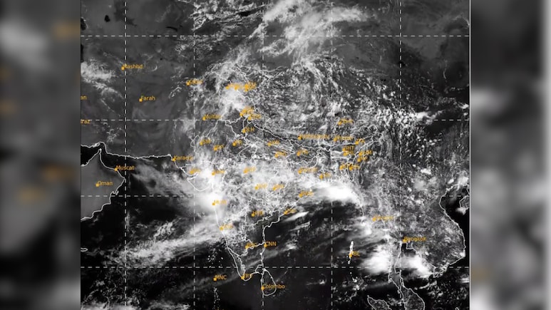
Fresh satellite images have revealed a striking rain belt stretching between 7,000 and 10,000 kilometres, extending from northern India across the Himalayas and China to South Korea. The extraordinary cloud formation marks one of the most vigorous phases of the 2026 southwest monsoon.
The 7,000-10,000 km cloud band has fuelled heavy rainfall across more than a dozen Indian states, with IMD warning of continued intense showers in several regions.
Latest Satellite animation pic.twitter.com/KDgBSls1bT
Also Read | Layoffs Are Rising In Tech, But These Skills Are Helping People Unlock Better Pay
— India Meteorological Department (@Indiametdept) July 23, 2026
Meteorologists identify the feature as a monsoon convergence zone, created when moisture-rich winds from the Indian Ocean collide with weather systems in Asia. The result is a broad and nearly uninterrupted corridor of cloud cover and rainfall extending across thousands of kilometres.
According to a report, weather experts have described the episode as a "massive monsoon day", citing rainfall that far exceeded long-term averages across many regions.
Satellite images capture an expansive blanket of cloud covering large parts of central, northern and eastern India, with the system continuing across the Himalayan range towards China and Japan.
The cloud belt has developed along an active monsoon trough that is drawing moisture-rich winds from the Indian Ocean. As this warm air rises and cools, it forms dense rain clouds, resulting in widespread rainfall stretching from India across much of Asia.
Meteorologists believe the latest downpours will strengthen seasonal rainfall totals, particularly in northern and central parts of the country.
The latest monsoon surge has delivered widespread heavy rain across Uttar Pradesh, Uttarakhand, Punjab, Haryana, Delhi-NCR and parts of Rajasthan. Meanwhile, eastern and northeastern states remain under the influence of low-pressure systems originating over the Bay of Bengal, bringing further spells of intense rainfall.
The vigorous monsoon has also raised the possibility of weather-related disruptions. Officials have warned that continued rainfall could trigger flash floods, urban flooding, landslides and rising river levels over the next few days, with the Himalayan states of Uttarakhand and Himachal Pradesh considered particularly vulnerable.
These satellite images offer a reminder that the southwest monsoon is not confined to India alone. Instead, it is part of a sprawling atmospheric circulation that drives weather across much of Asia, connecting the Arabian Sea with the western Pacific through an interconnected system of winds and clouds.
As the monsoon remains highly active, meteorologists expect the vast cloud band to continue influencing weather across India and neighbouring Asian countries over the coming days, bringing both much-needed rainfall and the risk of flooding in vulnerable regions.
Essential Business Intelligence, Sharp Market Insights, Practical Personal Finance Advice, Daily Fuel, Gold and Silver Prices and Latest Stories — On NDTV Profit.