
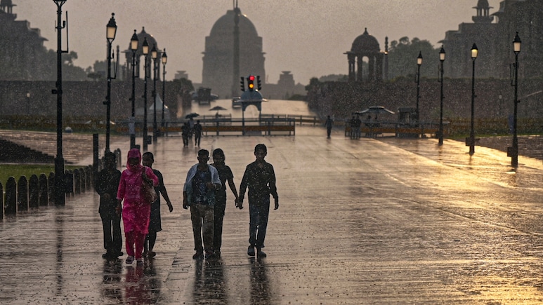
Heavy rainfall lashed Delhi-NCR on Monday morning, flooding roads and affecting traffic across several parts of the region, with the India Meteorological Department (IMD) issuing a red alert for the city and orange alerts for some nearby areas.
The IMD has forecasted a red alert at Central Delhi, East Delhi, New Delhi, North Delhi, North East Delhi, North West Delhi, Shahadra, South Delhi, South East Delhi, South West Delhi, West Delhi. The areas are very likely to witness heavy rainfall accompanied by thunderstorms and winds with speeds up to 60 kilometres per hour in the next three hours.
Meanwhile, the IMD has forecasted an orange alert for areas in Haryana and Uttar Pradesh. The areas are as follows- Faridabad, Gurgaon, Rohtak, Sonipat, Amroha, Baghpat, Bijnor, Bulandsahar, Gautam Budh Nagar, Ghaziabad, Hapur, Meerut and Sambhal. The areas are very likely to witness moderate to heavy rainfall accompanied by thunderstorms and winds with speeds up to 40-60 kilometres per hour in the next three hours.
Also Read | Layoffs Are Rising In Tech, But These Skills Are Helping People Unlock Better Pay
In a post on X, IMD shared the nowcast warning for Delhi-NCR. "IMD district wise nowcast warning. Valid for the next 3 hours," wrote the weather agency.
IMD DISTRICT-WISE NOWCAST WARNING Valid for the next 3 hours Issue Time: 12-10-2026 06:00 Hrs IST Valid Up To: 12-10-2026 09:00 Hrs IST 🔴 RED WARNING — TAKE ACTION Lightning/thunderstorms with gusty winds around 60 kmph and heavy rain above 15 mm/hour are very likely over: * Delhi: Central Delhi, East Delhi, New Delhi, North Delhi, North East Delhi, North West Delhi, Shahadra, South Delhi, South East Delhi, South West Delhi, West Delhi 🟠 ORANGE ALERT — BE PREPARED Thunderstorms and lightning with gusty winds of 40–60 kmph and moderate to intense rain of 5–15 mm/hour are likely over: * Haryana: Faridabad, Gurgaon, Rohtak, Sonipat * Uttar Pradesh: Amroha, Baghpat, Bijnor, Bulandsahar, Gautam Budh Nagar, Ghaziabad, Hapur, Meerut, Sambhal ⚠️ Safety Advisory: Stay alert and take necessary precautions. Do not shelter under trees or weak structures. Check road and traffic conditions, avoid flood/landslide-prone areas, and follow official advice. MORE DETAILS (including Yellow warnings) https://t.co/lQ5xJbGQ5f ──────────────────────────── India Meteorological Department Ministry of Earth Sciences
— India Meteorological Department (@Indiametdept) October 12, 2026
ALSO READ: IndiGo Delhi-Chennai Flight Diverted After Power Bank Catches Fire On Board
Visuals shared by ANI from Delhi's Mahipalpur Flyover showed a stretch of road waterlogged, with bikes and cars wading through waterlogged roads.
#WATCH | Delhi: Rainfall triggers waterlogging in parts of the city. Visuals around Mahipalpur Flyover. https://t.co/71aZK81IhU
— ANI (@ANI) October 12, 2026
Another visual by ANI, shows people wadding through waterlogged streets in the Jhandewalan Temple area.
#WATCH | Delhi: Rainfall triggers waterlogging in the Jhandewalan Temple area. https://t.co/XV1ifk65c4
— ANI (@ANI) October 11, 2026
The IMD has asked citizens to stay alert and take necessary precautions. "Do not shelter under trees or weak structures. Check road and traffic conditions, avoid flood/landslide-prone areas, and follow official advice," wrote IMD on X.
However, the IMD's forecast indicates that maximum temperatures are likely to remain between 31 and 35 degrees Celsius during the coming days.
The IMD said maximum temperatures across Delhi had fallen by 1-2 degrees Celsius over the past 24 hours, with no significant change in minimum temperatures. Minimum temperatures ranged between 21 and 24 degrees Celsius, while maximum temperatures remained between 30 and 32 degrees Celsius.
ALSO READ: Nana Patekar Died Of Heart Attack Caused By Blood Clot In Coronary Artery: Autopsy Report
Essential Business Intelligence, Sharp Market Insights, Practical Personal Finance Advice, Daily Fuel, Gold and Silver Prices and Latest Stories — On NDTV Profit.