
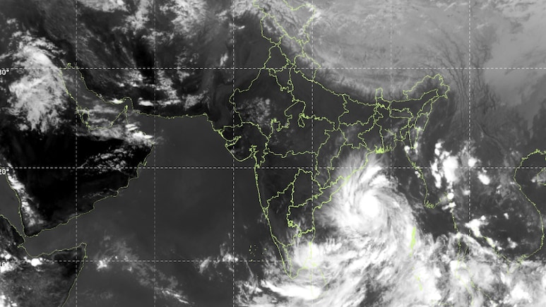
Cyclone Arnab is forecast to make landfall along the Andhra Pradesh and Yanam coasts on the forenoon of October 28, bringing the risk of strong winds, extremely heavy rainfall and coastal inundation, according to the India Meteorological Department's (IMD) bulletin issued on October 26.
The storm is expected to intensify as it moves northwestwards over the Bay of Bengal, with maximum sustained wind speeds of 115-125 kmph and gusts of up to 140 kmph during landfall.
The IMD has warned of heavy to extremely heavy rainfall in several districts of coastal Andhra Pradesh, along with the risk of storm-surge inundation in low-lying coastal areas. Fishermen have been advised not to venture into affected parts of the Bay of Bengal and adjoining coastal waters.
Also Read | Layoffs Are Rising In Tech, But These Skills Are Helping People Unlock Better Pay
When Will Cyclone Arnab Make Landfall?
According to the IMD's October 26 bulletin, Cyclone Arnab is very likely to make landfall during the forenoon of October 28.
The weather system is forecast to move west-northwestwards and intensify into a severe cyclonic storm over the west-central Bay of Bengal by midnight on October 26. It is then expected to strengthen further into a very severe cyclonic storm on October 27 before moving northwestwards towards the coast.
The IMD has forecast maximum sustained wind speeds of 115-125 kmph, with gusts reaching 140 kmph, during landfall.
The storm is expected to weaken gradually after crossing the coast. The precise timing and intensity of its movement after landfall will depend on subsequent forecasts.
ALSO READ | Cyclone Arnab Likely To Hit Andhra Coast On Oct. 28: IMD
Where Will Cyclone Arnab Hit The Coast?
The IMD has forecast that Cyclone Arnab will cross the Andhra Pradesh and Yanam coasts between Bapatla and Visakhapatnam, close to Yanam, during the forenoon of October 28.
The forecast identifies a stretch of the Andhra Pradesh coastline as the primary area of concern. The storm's impact is expected to extend across several coastal districts, including Bapatla, Krishna, NTR, Eluru, West Godavari, East Godavari, Kakinada, Anakapalli and Visakhapatnam.
Kakinada and Yanam, which is part of the Union Territory of Puducherry, have been identified as particularly vulnerable to storm-surge inundation.
The IMD has forecast a storm surge of 1.0-1.5 metres above the astronomical tide, which could inundate low-lying areas of Andhra Pradesh during landfall. The maximum peak surge is expected near Kakinada and Yanam.
The forecast identifies the likely landfall corridor rather than a single, precise point. The timing and location may be refined in subsequent IMD updates.
How Strong Will Cyclone Arnab Be?
Cyclone Arnab is forecast to make landfall as a very severe cyclonic storm, with sustained winds of 115-125 kmph and gusts of up to 140 kmph.
The IMD has warned that the winds could destroy thatched houses and cause extensive damage to kutcha houses. Some damage to pucca houses is also possible, while large trees could be uprooted and power and communication poles could bend or break.
Agriculture could also be affected, with standing crops, plantations and orchards vulnerable to strong winds. Banana, papaya and drumstick trees are among the crops identified as being at risk.
Sea conditions are expected to deteriorate as the storm intensifies. The IMD has forecast very rough to high seas over parts of the Bay of Bengal, with conditions expected to remain dangerous around the storm.
ALSO READ | Cyclone Arnab: Andhra Pradesh Braces For Landfall; Odisha Bans Fishing In Sea, Tourist Entry In 6 Districts
Which States And Districts Are Under Alert?
Coastal Andhra Pradesh is expected to face the most significant rainfall threat. The IMD has forecast light to moderate rainfall at most places, with heavy to very heavy rainfall at several locations on October 27 and 28.
Extremely heavy rainfall is likely at isolated places in Anakapalli, Kakinada, Dr B.R. Ambedkar Konaseema, East Godavari, West Godavari and Eluru districts, as well as Yanam.
Heavy to very heavy rainfall is forecast in Srikakulam, Parvathipuram Manyam, Vizianagaram, Alluri Sitharama Raju, Visakhapatnam, NTR, Krishna, Guntur and Bapatla districts. Palnadu, Prakasam and Sri Potti Sriramulu Nellore districts are also under a heavy-rainfall warning.
The storm could affect areas beyond Andhra Pradesh. The IMD has forecast adverse weather along the adjoining Odisha coast, while parts of Tamil Nadu, Puducherry and West Bengal may also experience rain, strong winds or rough seas.
Interior districts of southern Odisha, southern Chhattisgarh and adjoining areas of northeast Telangana could experience strong winds on October 28.
What Is The IMD Warning?
The IMD has advised fishermen not to venture into the southwest and adjoining central Bay of Bengal, as well as along and off the Andhra Pradesh, Odisha and Yanam coasts, during the October 26-29 period.
Authorities and residents in vulnerable coastal areas have been advised to prepare for the storm's impact and follow official instructions. People living in vulnerable structures should pay attention to local safety advisories and move to safer locations if directed by the authorities.
The weather agency has warned of possible coastal flooding and inundation of low-lying areas due to the forecast storm surge. Heavy rainfall could also lead to waterlogging and disruption to transport and essential services in affected areas.
Ports along the Andhra Pradesh coast have issued warning signals as the storm approaches. The IMD has urged residents, fishermen, maritime operators and local authorities to monitor subsequent advisories for updates to the forecast.
The landfall timing, intensity, rainfall warnings and affected areas described above are based on the IMD bulletin issued on October 26, 2026, and should be updated against the latest bulletin before publication.
Essential Business Intelligence, Sharp Market Insights, Practical Personal Finance Advice, Daily Fuel, Gold and Silver Prices and Latest Stories — On NDTV Profit.