Once the storm intensifies into a cyclone, it will be named Nisarga, as per the new list of cyclone names approved by the World Meteorological Organisation. It will be the second cyclone over North Indian Ocean this season after Amphan.
Heavy rainfall is expected over Lakshadweep, north Kerala and coastal Karnataka during next 12 hours, IMD said in a release early Tuesday morning. The rains are projected to progress to south Konkan and Goa on June 2 and 3 and intensify into very heavy rainfall at isolated places.
India Meteorological Department warns of heavy to very heavy rainfall on Tuesday in parts of north Konkan and north Madhya Maharashtra region that may intensify into extremely heavy rain at isolated places on Wednesday and Thursday.
Parts of Gujarat, Daman, Dadra & Nagar Haveli is expected to witness heavy to very heavy rainfall on Wednesday that may intensify into extremely heavy rain in isolated instances on Thursday.
Depression over Eastcentral Arabian Sea near lat14.4°N and long 71.2°E about 300 km west-southwest of Panjim (Goa).
— India Met. Dept. (@Indiametdept) June 1, 2020
To intensify into Cyclonic Storm in24 hours. To cross north Maharashtra and south Gujarat coasts bet Harihareshwar(Raigad) and Daman in the afternoon of 03rd June . pic.twitter.com/7HoD9x7vlw
Expect heavy to very heavy rainfall in coastal areas of Maharashtra on June 3 as cyclone Nisarga advances over the Arabian Sea, IMD said at a media briefing on Monday.
IMD predicts heavy to very rainfall in districts including Sindhudurg, Ratnagiri, Thane, Raigad, Mumbai and Palghar. Isolated regions may receive extremely heavy rainfall of more than 20 cm on June 3, it said.
India Meteorological Department has retained the forecast for normal monsoon in India this year. IMD expects monsoon rains to be 102% of long-period average as the conditions become more favourable for good rains.
Region-wise monsoon distribution:
- North west: 107% of LPA
- Central India: 103% of LPA
- South peninsula: 102% of LPA
- North east: 96% of LPA
Monthly distribution of rains:
- July: 103% of LPA
- August: 97% of LPA
There is a higher probability of normal or above normal rainfall this monsoon season, according to the Met Department’s second forecast. The probability forecasts suggest a very low probability of deficient rains.
Probability Forecasts:
- Deficient rains (Below 90% of LPA): 5%
- Below normal (90%-96% of LPA): 15%
- Normal rainfall (96%-104% of LPA): 41%
- Above normal (104%-110% of LPA): 25%
- Excess (Above 110% of LPA): 14%
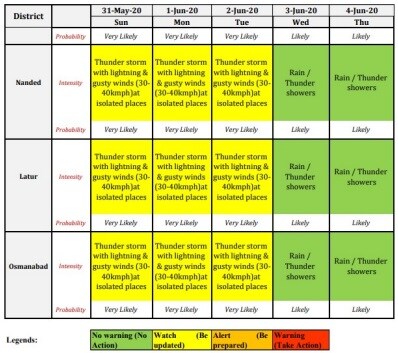
The Met department has forecasted light to moderate rainfall over Lakshadweep, north Kerala and coastal Karnataka on Monday with isolated instances of heavy rain.
South Konkan and Goa will also receive light to moderate rainfall at most places with heavy to very heavy rain at isolated regions between June 1 and June 3.
North Konkan region and the rest of the Maharashtra coast will witness rainfall on Wednesday and Thursday. IMD warns it could get heavy in some regions and extremely heavy in isolated instances.
Rains will hit Gujarat, Daman, Diu, Dadra & Nagar Haveli on June 3, which could gain strength on June 4 with extremely heavy rainfall in isolated regions.
The low-pressure area intensified into a depression today morning. To intensify into a Cyclonic Storm and cross North Maharastra and South Gujarat coast during 3rd June evening/night: IMD (India Meteorological Department) pic.twitter.com/1UFDyweABu
— ANI (@ANI) June 1, 2020
"An intense rainfall activity is expected due to the weather system," Devi added.
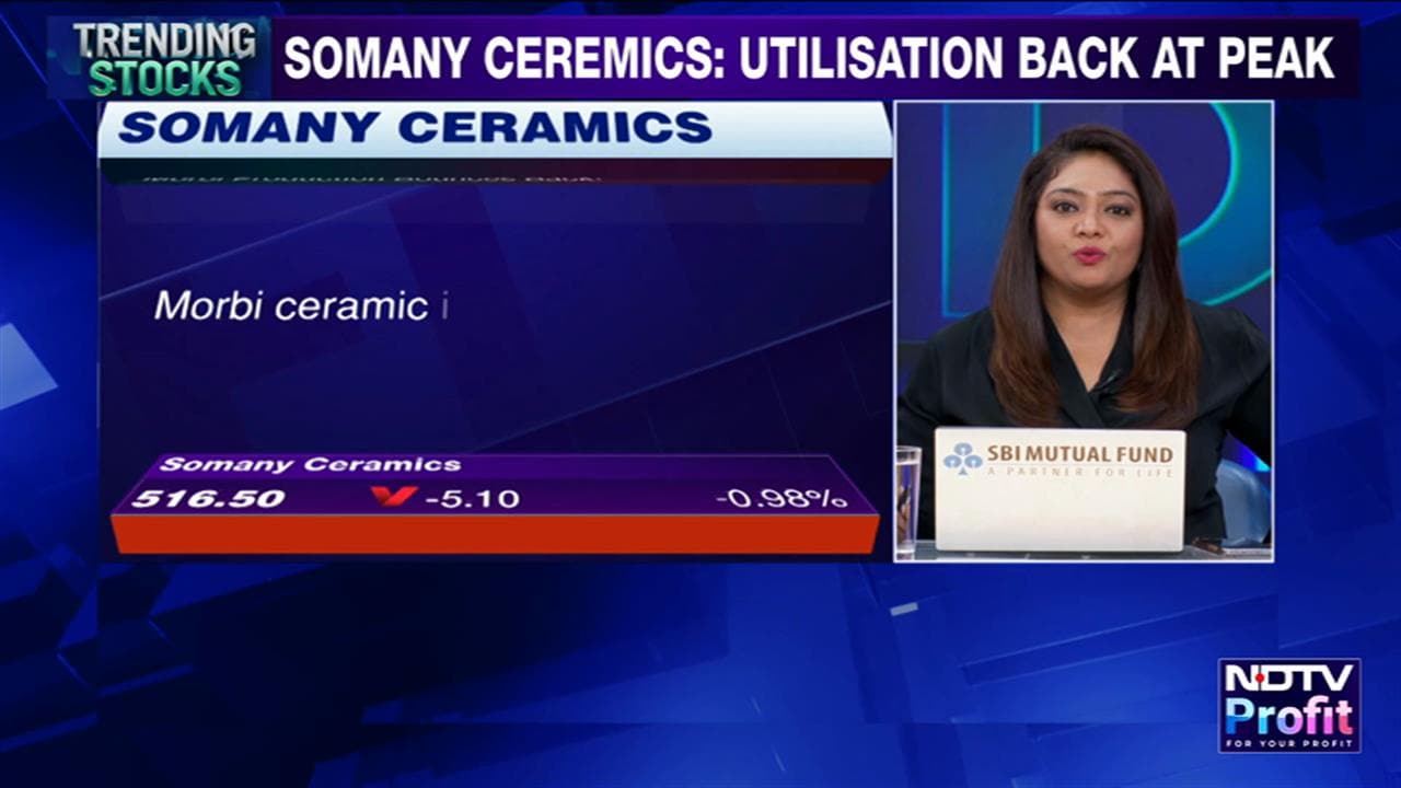
Essential Business Intelligence, Sharp Market Insights, Practical Personal Finance Advice, Daily Fuel, Gold and Silver Prices and Latest Stories — On NDTV Profit.