ADVERTISEMENT

Cyclone Nisarga Live Updates: Severe Cyclonic Storm To Cross Alibag On June 3 Afternoon 

Follow regular updates from the second cyclone to hit India in two weeks. 

Fishing boats anchored at the Uttan beach in Thane on June 1, following a warning by the Indian Meteorological Department for the fishermen to not enter the Arabian Sea for the next two days as a precaution against cyclone Nisarga. (Photographer: Mitesh Bhuvad/PTI)

The India Meteorological Department issued a warning to coastal Maharashtra and Gujarat for a severe cyclonic storm brewing in the Arabian Sea.

The deep depression over the Arabian Sea intensified into cyclonic storm ‘Nisarga’ at 11:30 a.m. on Tuesday, and is very likely to intensify into a severe cyclonic storm during next 12 hours, IMD said in an update.

The storm is expected to make landfall near the Maharashtra-Gujarat border between Harihareshwar and Daman, close to Alibag on Wednesday afternoon.

Cyclone Nisarga will be the second cyclone over North Indian Ocean this season after Amphan.

(Source: IMD)
(Source: IMD)

Navi Mumbai Police Issues Advisory

BMC Puts Out Dos And Don'ts For Mumbaikars

Cyclonic Storm ‘Nisarga' Formed

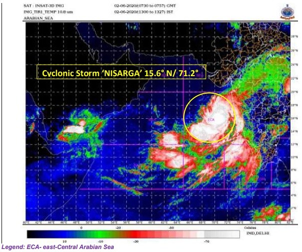
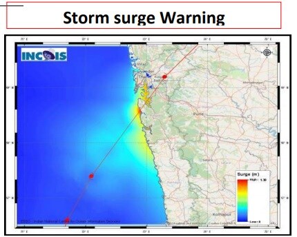
The deep depression over the Arabian Sea has intensified into cyclonic storm ‘Nisarga’ and lay centred about 280 km west-northwest of Panjim (Goa), 430 km south-southwest of Mumbai (Maharashtra) and 640 km south-southwest of Surat (Gujarat) at 11:30 a.m. on Tuesday, IMD said in an update.

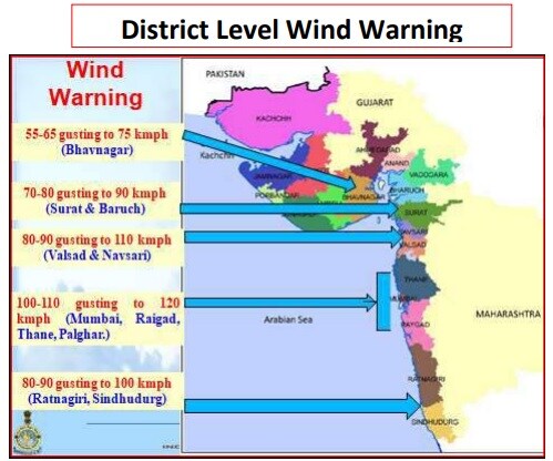
“It is very likely to intensify into a severe cyclonic storm during next 12 hours,” the Met Department said. “It is very likely to cross north Maharashtra and adjoining south Gujarat coast between Harihareshwar and Daman, close to Alibag on Wednesday afternoon as a severe cyclonic storm with a maximum sustained wind speed of 100-110 kmph gusting to 120 kmph.”

Over 20,000 People To Be Evacuated In Gujarat

Gujarat's Valsad and Navsari district administrations have started evacuating nearly 20,000 people from 47 villages located close to the state coastline, officials said on Tuesday.

"We have deployed our teams to shift nearly 10,000 people living in 35 coastal villages. We have already identified shelter homes and started the evacuation process," Valsad Collector RR Raval said.

In adjoining Navsari district also, the administration has initiated the process of shifting some 10,200 people from 12 villages, Collector Ardra Agarwal said.

(Source: PTI)

33 NDRF Teams Deployed In Maharashtra, Gujarat

Thirty-three National Disaster Response Force teams have been deployed in the coastal districts of Maharashtra and Gujarat in view of the impending Cyclone Nisarga, the chief of the federal contingency force said on Tuesday.

In a video message, NDRF Director General SN Pradhan said, "Gujarat and Maharashtra have 11 and 10 teams respectively and they are being deployed in the coastal districts facing the Arabian Sea".

On Gujarat's request, five more teams are being airlifted to the state from Punjab, he said.

Gujarat will have a total of 17 NDRF teams, including two on standby, and neighbouring Maharashtra 16 teams, including six on standby, he said.

An NDRF team has a strength of about 45 personnel and each unit is equipped with tree and pole cutters, communication gadgets, inflatable boats and a small basic medical unit.

(Source: PTI)

Brace For Cyclone Damage

  • Major damage to thatched houses/huts. Roof tops may blow off. Unattached metal sheets may fly.
  • Damage to power and communication lines.
  • Major damage to kutcha and some damage to pucca roads. Flooding of escape routes.
  • Breaking of tree branches, uprooting of large avenue trees. Damage to banana and papaya trees. Large dead limbs blown from trees.
  • Major damage to coastal crops.
  • Damage to embankments/salt pans
Opinion
Rare Cyclone to Disrupt Business in India’s Financial Hub

Wind Warning

Gale wind with speed reaching 80-90 kmph gusting to 100 kmph is expected to hit south Maharashtra and Goa coasts Tuesday evening, IMD said in a release.

The Gale wind will advance along Maharashtra coast with speed increasing to 100-110 kmph gusting to 120 kmph off Raigad, Mumbai, Palghar and Thane on Wednesday morning.

Gale wind, with speed reaching 80-90 kmph gusting to 100 kmph, is likely along Valsad and Navsari districts of Gujarat, Daman, Ratnagiri and Sindhudurg districts of Maharashtra from Wednesday afternoon. Meanwhile, Surat and Bharuch districts of south Gujarat, Dadra and Nagar Haveli will experience wind speed of 70-80 kmph gusting to 90 kmph. The remaining districts of south Gujarat coast will will see Squally wind of 50-60 kmph gusting to 70 kmph.

Squally wind of 50-60 kmph gusting to 70 kmph will also be experienced along and off Karnataka and Goa coasts during the next 24 hours.

(Source: IMD)
(Source: IMD)

IMD Warns Of Storm Surge Of 1-2 Meters In Mumbai

The deep depression over the Arabian Sea is very likely to intensify into a cyclonic storm during next six hours and further into a severe cyclonic storm during the subsequent 12 hours, the India Meteorological Department said in its update at 11:30 a.m.

Here are the other highlights from the IMD’s Cyclone Alert:

  • The weather system is very likely to cross Alibag on June 3 afternoon as a severe cyclonic storm, with a maximum sustained wind speed of 100-110 kilometers per hour, gusting up to 120 kmph.
  • Expect light to moderate rainfall at most places with heavy-to-very heavy rainfall at a few places.
  • Extremely heavy rainfall (≥ 20 centimetres in 24 hours) “very likely” at isolated places over north Konkan (Mumbai, Palgar, Thane, Raigad districts) and north Madhya Maharashtra.
  • Storm surge of about 1-2 meters height above astronomical tide is very likely to inundate low lying areas of Mumbai during the time of landfall.
(Source: IMD)
(Source: IMD)