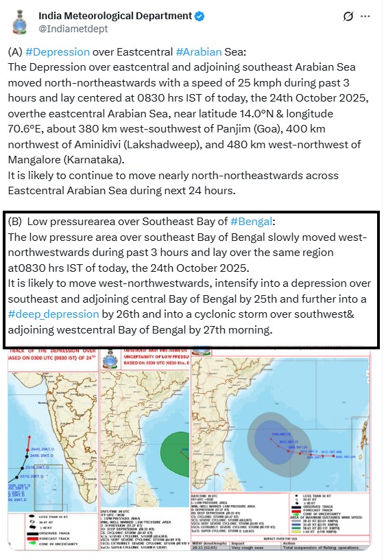
The India Meteorological Department (IMD) has warned about the formation of a cyclonic storm over the Bay of Bengal in the coming week. In its latest update on Friday, the weather agency reported that a low-pressure area has formed over the Bay of Bengal and is expected to intensify into a deep depression by October 26 and into a cyclonic storm over the southwest & adjoining west-central Bay of Bengal by October 27th morning.
The coastal regions of Tamil Nadu, Andhra Pradesh may experience rough sea conditions, heavy rainfall, and strong winds as a result of the adverse weather conditions.
Once the deep depression intensifies into a cyclonic storm, it will be called 'Cyclone Montha'.

image source: x.com/Indiametdept
What Does Montha Mean?
The name MONTHA, suggested by Thailand, means "fragrant flower" or "beautiful flower" in the Thai language. The name is part of the naming system for tropical cyclones in the North Indian Ocean. Cyclones in this region are named by the World Meteorological Organization (WMO)/ESCAP Panel on Tropical Cyclones, which includes 13 member countries (Bangladesh, India, Iran, Maldives, Myanmar, Oman, Pakistan, Qatar, Saudi Arabia, Sri Lanka, Thailand, United Arab Emirates, and Yemen). Each country provides a list of names, which are used sequentially. The primary purpose of naming is to facilitate easier identification, tracking, and disaster awareness.
Chennai And Tamil Nadu Rainfall Alert
The Regional Meteorological Centre of Chennai has issued the following weather warnings for Tamil Nadu, Puducherry & Karaikal areas.
26th October: Light to moderate rain at a few places with thunderstorm & lightning at one or two places is likely to occur over Tamil Nadu, Puducherry and Karaikal area. Heavy rain is likely to occur at isolated places over Tiruvallur, Chennai, Chengalpattu, Kancheepuram, Ranipet, Villuppuram districts and Puducherry.
27th October: Light to moderate rain at a few places with thunderstorm & lightning at one or two places is likely to occur over Tamil Nadu, Puducherry and Karaikal area. Heavy rain is likely to occur at isolated places over Kancheepuram, Chengalpattu, Tiruvallur, Chennai and Ranipet districts.
28th October: Light to moderate rain is likely to occur at a few places over Tamil Nadu, Puducherry, and Karaikal area. Heavy rain is likely to occur at isolated places over Kancheepuram, Chengalpattu, Tiruvallur, Chennai and Ranipet districts.
29th October: Light to moderate rain is likely to occur at isolated places over Tamil Nadu, Puducherry and Karaikal area.
Fishermen are advised not to venture off the Tamil Nadu coast, over Gulf of Mannar and the Comorin area during the above-mentioned period. Fishermen out at sea are advised to return to the coast by the evening of October 24.
Twin Cyclones Approaching Indian Coastline?
Weather Disturbance in Arabian Sea: As per IMD's latest update, an existing low-pressure area over the east-central Arabian Sea has intensified into a depression and has moved north-northeastwards with a speed of 25 kmph during the past 3 hours and lies centered at 0830 hrs IST of today (October 24) over the east-central Arabian Sea. It is about 380 km west-southwest of Panjim (Goa), 400 km northwest of Aminidivi (Lakshadweep), and 480 km west-northwest of Mangalore (Karnataka). It is likely to continue to move nearly north-northeastwards across the Eastcentral Arabian Sea during the next 24 hours.
Most weather models indicate initial northwestward movement of the existing depression till October 26. This will be followed by northeastward movement till October 28 over the Southeast Arabian Sea and adjoining central Arabian Sea during next 4-5 days. There is a large variation among models with respect of the movement of the system.
However, as of now further intensification is not indicated by the models.
(A) #Depression over Eastcentral #Arabian Sea:
October 24, 2025
The Depression over eastcentral and adjoining southeast Arabian Sea moved north-northeastwards with a speed of 25 kmph during past 3 hours and lay centered at 0830 hrs IST of today, the 24th October 2025, overthe eastcentral Arabian… pic.twitter.com/3ILmziNg0fEssential Business Intelligence, Continuous LIVE TV, Sharp Market Insights, Practical Personal Finance Advice and Latest Stories — On NDTV Profit.


